
We took a mid-morning train from Ollantaytambo to Aguas Clientes, the town below Machu Picchu.
We checked in to our hotel, then waited for a bus to take us up the steep switchbacks to the entrance.
We followed the roped pathways along Circuito 2, up to the agricultural terraces, along the urban area,
and back across the lower city.

Aguas Calientes looked tiny from Machu Picchu

Llamas wander the agricultural terraces near the entrance.


We started going up to the Superior Terraces.

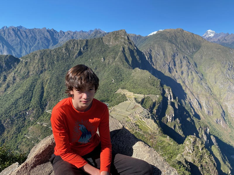
view from the Superior Terraces


walking into the urban area through a trapezoidal door

Viscachas look like rabbits with squirrel tails, and are closely related to chinchillas.
Viscachas look like a cross between a squirrel and a rabbit.


looking over the Temple of the Sun with the town of Aguas Calientes far below

This area was used as a quarry for building material.

looking across the plaza

We walked down the steps to the edge of the urban area.


looking back toward the agricultural terraces and entrance

looking up toward the Temple of the Three Windows

This viscacha was almost invisible until it moved.

A very friendly black cat lived around our hotel.

looking uphill in Aguas Calientes

We got up early, had breakfast in our hotel, and got right onto a bus up the hill at 7am. Our tickets
said we needed to check in at the Wayna Picchu trailhead by 8am. We followed Circuito 4 along the plaza
to the entrance to Waynu Picchu, the steep mountain the background of the postcard Machu Picchu.
The trail to the top is mostly 500 year old stairs. As we got closer the top, the stairs were smaller
and steeper. From the top, we had 360 degree views of giant montains, with Machu Picchu below. Down from
the mountain, we walked through the Temple of the Condor on our way back to the gate.

The next morning, we followed Circuito 4.

The paths are laid out with ropes.

looking up toward the urban section

the Temple of the Sun from below


looking down toward the Urubamba River

After signing in, we started up the steep trail to Wayna Picchu.

The trail was mostly steep stairs.


The stairs were often narrow, uneven, and steep.

Yes, this is actually the trail.

These stairs were not deep enough for our whole foot.

As we got closer to the top, we could see Machu Piccu far below.

Even more stairs to get to the top.

The house was probably used by priests.

Even higher up, we could see the road to town zigzagging down the mountain.


We climbed down from the summit on a different route.


The trail disappeared into a cave.

We had to squeeze through the entrance, and couldn't stand upright inside.


The stairs went down between agricultural terraces.


map of the Wayna Picchu trail; we took about an hour to go up, and half an hour down

After leaving Wayna Picchu, we walked along the lower edge of Machu Picchu.

The Incas carved the rock on the ground into the shape of a condor head and ruff; the natural rocks above are the wings.

The fountains still carry water.

looking back over Machu Picchu on our way out


The hotel cat was available for snuggles when we went back to our hotel.